The Grey Panthers
Walks in the NORTH YORKSHIRE (WEST) Area
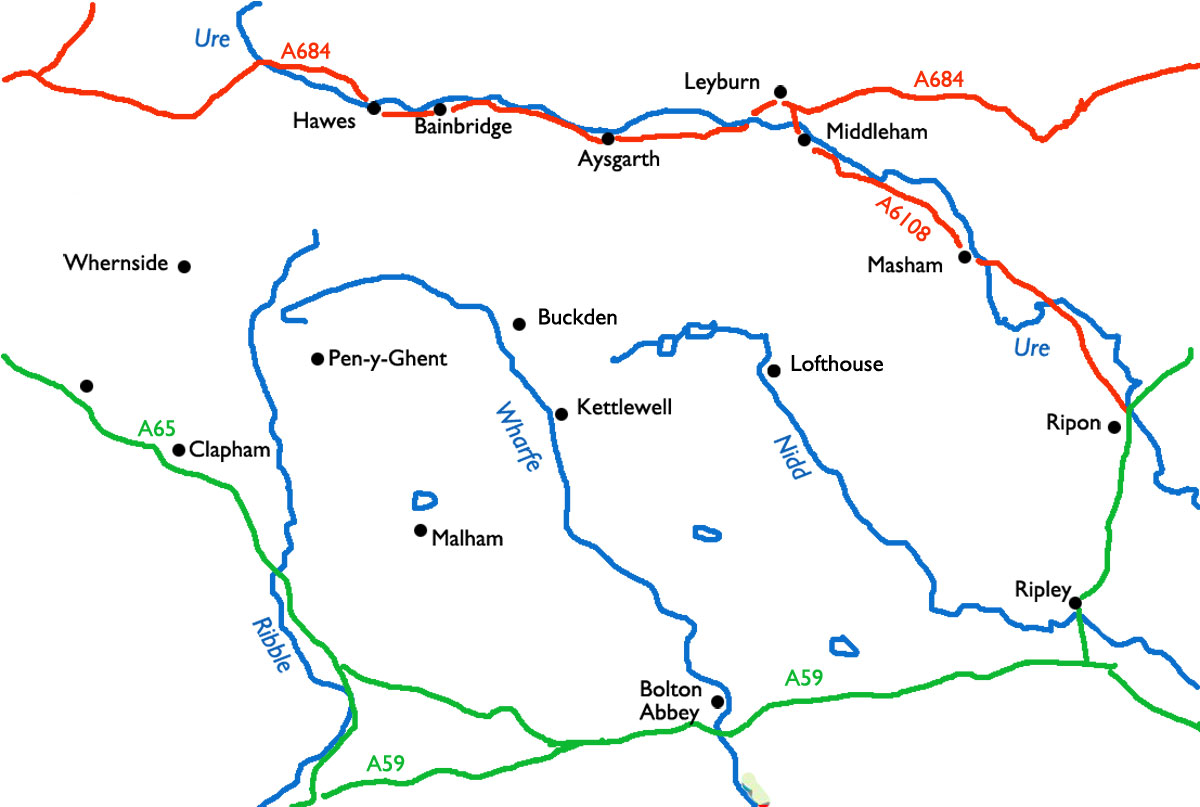
Select the image above for a larger sized map, which will help you select one of the routes (below).
The larger sized map opens in a new window (close it to return to this page). Press <Ctrl><P> if you want to print it.
Start From |
Route |
Distance |
||
| Askrigg | to Carperby | 9.5 miles | ||
| Askrigg | to Hawes via the Cam High Road | 12.4 miles | ||
| Aysgarth | to Askrigg | 10.1 miles | ||
| Aysgarth | to West Burton and West Witton | 10.1 miles | ||
| Bainbridge | to Askrigg | 10.9 miles | ||
| Bainbridge | to Marsett, Stalling Busk & Semer Water | 9.4 miles | ||
| Bainbridge | Semerwater and Stalling Busk | 10.1 miles | ||
| Bolton Abbey | to Simon's Seat and Lord's Seat | 10.2 miles | ||
| Bolton Abbey | to the Strid | 6.2 miles | ||
| Buckden | to Buckden Pike and Starbotton | 8.3 miles | ||
| Buckden | to Cray, Yockenthwaite, & Hubberholme. | 7.3 miles | ||
| Buckden Pike | from Walden Head (*) | 10.5 miles | ||
| Castle Bolton (1) | to Aysgarth | 9.9 miles | ||
| Castle Bolton (2) | to Aysgarth | 10.1 miles | ||
| Carlton | Coverdale circular | 10.7 miles | ||
| Clapham | to Ingleborough and Sulber Nick | 11.2 miles | ||
| Fountains Abbey | to Markenfield Hall and the Studley Royal Park | 10.8 miles | ||
| Fountains Abbey | to Sawley and Bishop Thornton | 11.6 miles | ||
| Hawes | to Shivery Gill | 9.0 miles | ||
| Hawes | and the Red Squirrel Trail | 10.0 miles | ||
| Leyburn (1) | to Redmire (1) | 10.6 miles | ||
| Leyburn (2) | to Redmire (2) | 11.0 miles | ||
| Leyburn (3) | to Redmire (3) | 10.0 miles | ||
| Litton | to Pen-y-Ghent | 13.6 miles | ||
| Lofthouse | to Scar House Reservoir & How Stean Gorge | 9.7 miles | ||
| Malham | Malham Cove and Gordale Scar | 9.5 miles | ||
| Malham | Gordale Scar and Malham Cove | 9.95 miles | ||
| Masham | to the Druid's Temple | 11.2 miles | ||
| Masham | to Fearby | 10.4 miles | ||
| Masham | to Limehouse Hill via the Ripon Rowel Way | 7.5 miles | ||
| Ripley | to Burnt Yates, Birstwith, & Hampsthwaite | 11.0 miles | ||
| Ripon | to Bishop Monkton & Wormald Green | 10.7 miles | ||
| Ripon | to Fountains Abbey | 9.6 miles | ||
| Sawley | to High Grantley | 11.4 miles | ||
| Thornton Rust | Addlebrough and Aysgarth | 11.4 miles | ||
| Thornton Rust | to Cubeck and Stake Fell | 10.0 miles | ||
| Thornton Steward | to Jervaulx Abbey and Spennithorne | 10.4 miles | ||
| Wensley Bridge | to Middleham | 9.8 miles | ||
| West Burton | to Carlton | 9.8 miles | ||
| West Burton | to Thoralby and Walden Dale | 9.6 miles | ||
| West Burton | to Walden Beck Dale | 9.9 miles | ||
| West Tanfield | to Hackfall Woods | 10.0 miles | ||
| West Tanfield | to Mickley and Grewelthorpe | 11.5 miles | ||
| West Tanfield | to Sharrow | 11.3 miles | ||
| West Witton | to West Burton and Penhill | 10.4 miles | ||