The Grey Panthers
Walks in the NORTH YORK MOORS (NORTH WEST) Area

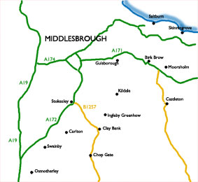
Select the image above for a larger sized map, which will help you select one of the routes (below).
The larger sized map opens in a new window (close it to return to this page). Press <Ctrl><P> if you want to print it.
Start From |
Route |
Distance |
||
| Arden Great Moor and Thorodale | 10.7 miles | |||
| Bank Foot | to Baysdale Abbey | 11.9 miles | ||
| Birk Brow | to Commondale | 11.3 miles | ||
| Birk Brow | to Commondale | 11.8 miles | ||
| Carlton Bank | to Scugdale and Snotterdale | 7.9 miles | ||
| Castleton | to Danby Dale and Brotton Village | 8.2 miles | ||
| Castleton | to Danby Dale and Little Fryup Dale | 7.7 miles | ||
| Chop Gate | to Bilsdale East Moor | 12.5 miles | ||
| Chop Gate | to Fangdale Beck | 10.6 miles | ||
| Chop Gate | to Round Hill and Urra | 9.0 miles | ||
| Chop Gate | to Tripsdale and the Ship Stone | 11.4 miles | ||
| Chop Gate | to Tripsdale, Bransdale, and Bloworth Crossing | 13.0 miles | ||
| Chop Gate | to the Wainstones | 10.2 miles | ||
| Clay Bank | to Chop Gate | 9.8 miles | ||
| Clay Bank | to Ingleby Moor by the Incline | 11.9 miles | ||
| Cockayne | to Bransdale Mill and Rudland Rigg | 10.2 miles | ||
| Flatts Lane Country Park | to Eston Nab | 7.4 miles | ||
| Great Ayton | to Kildale | 10.4 miles | ||
| Guisborough | to the Hanging Stone and Hutton Village | 9.5 miles | ||
| Ingleby Arncliffe | to Stainton via Arncliffe Woods | 8.0 miles | ||
| Ingleby Greenhow | to Ingleby Moor and Battersby village | 11.0 miles | ||
| Ingleby Greenhow | to Low Harm and Ingleby Moor | 10.2 miles | ||
| Kildale | to Baysdale (via Hob Hole) | 10.5 miles | ||
| Kildale | to Ingleby Moor | 10.9 miles | ||
| LIngdale | to Boosbeck | 10.6 miles | ||
| Moorsholm | Kilton Castle and Liverton circular | 11.7 miles | ||
| Newton-under-Roseberry | to Roseberry Topping and Great Ayton & Gisborough Moors | 10.5 miles | ||
| Newton-under-Roseberry | to Roseberry Topping and Old Nunthorpe Village | 8.0 miles | ||
| Osmotherley | to Ingleby Arncliffe | 8.9 miles | ||
| Osmotherley | to Nether Silton & Over Silton | 9.2 miles | ||
| Osmotherley | to Oak Dale, Sheepwash, and the Cod Beck Reservoir. | 7.5 miles | ||
| Saltburn (1) | to Skinningrove | 10.9 miles | ||
| Saltburn (2) | to Skinningrove | 11.2 miles | ||
| Saltburn | to Upleatham and Skelton | 9.7 miles | ||
| Slapewath | to Skelton and Upleatham | 9.5 miles | ||
| Skinningrove | and Boulby | 10.4 miles | ||
| Swainby | to Arncliffe Woods, Faceby, and Whorlton Castle | 10.4 miles | ||
| Swainby | to Carlton Bank via Scugdale Hall | 9.26 miles | ||
| Thimbleby | Nether Silton | 11.1 miles | ||
| Westerdale | and Westerdale Moor | 9.1 miles | ||